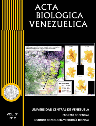
APPLICATION OF SATELLITE IMAGES TO STUDY THE DISTRIBUTION OF Rhodnius pallescens BARBER 1932, VECTOR OF CHAGAS DISEASE
Palabras clave:
Rhodnius pallescens, Chagas disease, Geographic Information Systems, Satellite images, AVHRR, maximum entropy.Resumen
Chagas disease is the most disabling disease in Latin America. Because the current increase of global human migration threatens to widen the disease range, , including vector borne diseases, to study the distribution of insect vectors becomes an important task. Rhodnius pallescens is the main Chagas disease vector in Panama, and a secondary one in Colombia, Nicaragua and Costa Rica. Given their wild habits, their distribution could be highly influenced by climatic factors. In this study we built a geographical distribution model of this vector using the method of maximum entropy (Maxent) to identify sites having the highest occurrence probability of finding the vector species. The results obtained demonstrate that the sites predicted by the model, as those with the greatest occurrence probability, fitted with those already recorded in the field as vector presence sites. The high sensitivity of the prediction was evidenced by the value of the area under the ROC curve (AUC=0.995).